lsugolfredman
| Favorite team: | LSU |
| Location: | |
| Biography: | |
| Interests: | |
| Occupation: | |
| Number of Posts: | 1942 |
| Registered on: | 6/25/2005 |
| Online Status: | Not Online |
Recent Posts
Message
re: Gulf shrimp
Posted by lsugolfredman on 7/8/26 at 8:11 pm to Sailorjerry
I’ve been buying from Sandy’s on Airline Hwy near Tom Drive for a few years now. Some occasional runts in the mix, but always solid for freshness and availability

 0
0
Louisiana Cajun Reserve Crawfish Boil
Posted by lsugolfredman on 3/18/26 at 10:10 pm
Saw this on the shelf in Rouses. Anyone given this a whirl?
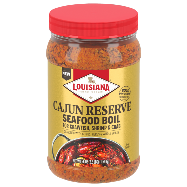
Ingredient listing is generic. On appearance alone, it looks very similar to the Geaux Creole brand with larger chunks of bay leaves and spices.
Ingredient listing is generic. On appearance alone, it looks very similar to the Geaux Creole brand with larger chunks of bay leaves and spices.
re: 1/25-1/26 2026 Major Deep South Winter Storm Thread
Posted by lsugolfredman on 1/24/26 at 2:11 pm to Mr Roboto
The WRF-ARW model also brings the line close, which has been the best at mirroring the actual temps.

re: 1/25-1/26 2026 Major Deep South Winter Storm Thread
Posted by lsugolfredman on 1/24/26 at 2:02 pm to jaytothen
Yep, Ice line is significantly further south and east on the latest HRRR run.
Knocking on BRs doorstep.
Knocking on BRs doorstep.
re: 1/25-1/26 2026 Major Deep South Winter Storm Thread
Posted by lsugolfredman on 1/21/26 at 4:09 pm to LSUsmartass


re: 1/25-1/26 2026 Major Deep South Winter Storm Thread
Posted by lsugolfredman on 1/21/26 at 1:31 pm to deltaland
It is notable that the Euro model is being discounted by a senior met on another forum, indicating that the temperature is far too warm and too slow with the cold air.
How that impacts South LA is anyone’s guess
How that impacts South LA is anyone’s guess
re: 1/25-1/26 2026 Major Deep South Winter Storm Thread
Posted by lsugolfredman on 1/21/26 at 1:26 pm to jmcwhrter
HRRR only goes to 48 hrs bud.
And the 48 hr version is only run 4 times daily, otherwise it’s 18hr increments.
Must be confused
And the 48 hr version is only run 4 times daily, otherwise it’s 18hr increments.
Must be confused
re: Corn and crab bisque question
Posted by lsugolfredman on 12/16/25 at 7:51 pm to kayjay
If you are looking for a readily available product that works great to fill the flavor void, this stuff is great.

re: Duck Season 2025/2026
Posted by lsugolfredman on 11/13/25 at 9:42 am to Kvothe
Are we going to get a waterfowl survey report released before opening weekend this year?
Last year it was uploaded on November 8th....
Last year it was uploaded on November 8th....
re: Guess who’s back……… back again
Posted by lsugolfredman on 10/29/25 at 9:11 am to Jack Daniel
Obligatory

re: SOLD - 4 (four) West side lower bowel tickets (in shade) vs SE - $100 for all
Posted by lsugolfredman on 9/20/25 at 12:27 pm to BRTigerDoc
Just sent you an email
re: Baton Rouge Tree Removal Services
Posted by lsugolfredman on 9/3/25 at 5:25 pm to ynlvr
Creels Tree Service
re: Hurricane Season - No Current Gulf Threats
Posted by lsugolfredman on 8/8/25 at 11:54 am to nicholastiger
Get ready for the onslaught of doom casters posting the latest GFS run. Yeah, that setup is Andrew-Esque, but its fantasy land.
re: Hurricane Season - We back - NHC 10% Gulf Action
Posted by lsugolfredman on 7/14/25 at 10:22 am to Tarps99
12z ICON looking ripe:

re: Looking for high temp cheese.
Posted by lsugolfredman on 2/10/25 at 12:48 pm to NOLAGT
Lil Butcher Shoppe in Hattiesburg always has a solid assortment of cheese. Give them a call.
Have a hard time spending less than $200 when I stop
Have a hard time spending less than $200 when I stop
re: Deep South winter storm and arctic outbreak - Jan. 20-23 timeframe
Posted by lsugolfredman on 1/20/25 at 10:31 pm to Dnorma2
Any doubt that the southern shift would remove snow chances in BR were erased on the latest run. Big cutoff north of EBR Parish, but this run just more than doubled its total from 2 hours ago from 2.3 to 4.8".

re: Deep South winter storm and arctic outbreak - Jan. 20-23 timeframe
Posted by lsugolfredman on 1/20/25 at 8:05 pm to msutiger
New NOAA snowfall projection map out of the Slidell office.

re: Deep South winter storm and arctic outbreak - Jan. 20-23 timeframe
Posted by lsugolfredman on 1/20/25 at 7:56 pm to RanchoLaPuerto
NAM rolling in sharing the love with Ellic and SW MS, compared to prior runs
Bodes well for SELA with a massive precip shield sliding southeast, here ya go...

Bodes well for SELA with a massive precip shield sliding southeast, here ya go...
re: Deep South winter storm and arctic outbreak - Jan. 20-23 timeframe
Posted by lsugolfredman on 1/20/25 at 7:25 pm to Lsupimp
0z HRRR bringing back some solid totals for the 10/12 stretch.

re: Deep South winter storm and arctic outbreak - Jan. 20-23 timeframe
Posted by lsugolfredman on 1/20/25 at 5:55 pm to Mr Roboto
Latest and greatest NOAA NWS snowfall blend of models:

re: Deep South winter storm and arctic outbreak - Jan. 20-23 timeframe
Posted by lsugolfredman on 1/19/25 at 10:58 am to moontigr
quote:
We were told to ignore the NAM
You’re referring to the low res NAM version that maintained a sleet vs snow line much further north (LA/MS state line). The much more high res version, 3km resolution, moves that line to the damn coast.
Popular