Started By
Message
re: designated "oh shite bad weather" thread | at least 5 dead in MS
Posted on 12/23/15 at 4:37 pm to Wishnitwas1998
Posted on 12/23/15 at 4:37 pm to Wishnitwas1998
If you're near Holly Springs and read this, you need to panic and get to safety five minutes ago.
 1
1


Posted on 12/23/15 at 4:39 pm to Duke
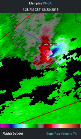
That hook echo in Holly Springs

This post was edited on 12/23/15 at 4:40 pm
Posted on 12/23/15 at 4:44 pm to HamzooReb
Classic Supercell.
I know the area well. Breaks my heart this close to the holidays.
I know the area well. Breaks my heart this close to the holidays.
Posted on 12/23/15 at 4:45 pm to Duke

Posted on 12/23/15 at 4:50 pm to WonderWartHawg
How wide do you think this tornado is?

Posted on 12/23/15 at 4:52 pm to HamzooReb
I'd guess you have a .5 mile wide wedgeish (wedge = wider than visibly tall) tornado right there.
Tornado Emergency for Benton County, MS.
Tornado Emergency for Benton County, MS.
Posted on 12/23/15 at 5:00 pm to Duke
Looks like one developing around Oxford
Posted on 12/23/15 at 5:00 pm to Duke
Weather channel really fricked this one up. Pumped it up with the PDS and Torcon of 8 for the Delta/North MS area and we had 1 tornado in the north half of the state 
I can't take those idiots serious anymore, they always over exaggerate. It's barely been a cloud where I'm at, not even a drop of rain and it's been taken out of the forecast entirely. 10% precipitation the next 6 hours with decreasing cloudiness. What a joke
I can't take those idiots serious anymore, they always over exaggerate. It's barely been a cloud where I'm at, not even a drop of rain and it's been taken out of the forecast entirely. 10% precipitation the next 6 hours with decreasing cloudiness. What a joke
Posted on 12/23/15 at 5:03 pm to deltaland
I'm pretty sure there's been more than 1 tornado. Sirens just started going off here in Alcorn County.
eta.
And stopped already. The one near Holly Springs looks to have done significant damage.
eta.
And stopped already. The one near Holly Springs looks to have done significant damage.
This post was edited on 12/23/15 at 5:05 pm
Posted on 12/23/15 at 5:04 pm to deltaland
You got capped along with most of the Gulf south. Got a little pool of warm air aloft just above the surface per the Jackson balloon a few hours ago. Top to bottom, there's plenty of lift potential...but there's a break stopping the lowest levels from lifting up.
Posted on 12/23/15 at 5:08 pm to Duke
Interesting. Just seems that they would know that and not freak everyone out and then not even get a clap of thunder..doesn't really lend the "experts" much credibility. Used to be everytime they announced an outbreak it would get rough for the area they targeted, but the past couple of years they've really missed the mark a lot it seems.
Looks like it will be much worse in east MS, west Alabama which is outside the PDS watch area. I think they missed the mark on this one..the delta rarely gets tornadoes the river seems to break up the storms and the flat land doesn't cause much instability for whatever reason. When it hits the hills around Winona is when it starts really ramping up most of the time
Looks like it will be much worse in east MS, west Alabama which is outside the PDS watch area. I think they missed the mark on this one..the delta rarely gets tornadoes the river seems to break up the storms and the flat land doesn't cause much instability for whatever reason. When it hits the hills around Winona is when it starts really ramping up most of the time
Posted on 12/23/15 at 5:10 pm to deltaland
Sirens back on again. This one is estimated to be 3/4 mile wide.


Posted on 12/23/15 at 5:13 pm to Duke
quote:
If he's heading to Oxford, he better be careful. If heading North, it's coming.
He just called again and stopped for a minute to take a break and check the radar. He's managed to get behind the line and should be ok where he's headed (not Oxford).
Posted on 12/23/15 at 5:14 pm to deltaland
The problem is you don't know the cap is there or not until the event is there. Models attempt to model a sounding (it's a Temp and humidity reading w/wind velocities up a column of air) but they're far from perfect.
They'd rather paint a broad brush than have an unexpected area get fricked by an outbreak. TWC also loves ratings...
They'd rather paint a broad brush than have an unexpected area get fricked by an outbreak. TWC also loves ratings...
Posted on 12/23/15 at 5:15 pm to HamzooReb
quote:
Sirens back on again. This one is estimated to be 3/4 mile wide.
3/4 mile, sweet Jesus I hope that bastard stays away from populated areas.

Posted on 12/23/15 at 5:16 pm to Wishnitwas1998
Watching James Spann
Posted on 12/23/15 at 5:19 pm to vuvuzela
It's going through some desolate country right now thankfully.
Posted on 12/23/15 at 5:19 pm to biggsc
Seeing rotation just SW of Oxford.
Posted on 12/23/15 at 5:22 pm to pankReb
I ended up having to work pretty much all day and had to abandoned the thread but I'm pretty much speechless right now. Some bad stuff has happened in holly springs no doubt, I'm 24 years old and that's the worst radar data/info I've ever seen. Ron Childress, a Memphis weatherman, said it was the worst he'd seen in 25 years on the job in the north Ms
Praying for my beloved Oxford as well
Praying for my beloved Oxford as well
This post was edited on 12/23/15 at 5:23 pm
Posted on 12/23/15 at 5:26 pm to Wishnitwas1998
Anyone have a good live stream?

 Page 3 of 7

Popular
Back to top