Started By
Message
Attention T Bird
Posted on 6/15/15 at 10:51 am
Posted on 6/15/15 at 10:51 am
tArk is going to need to make its way to Houston with all this rain coming.
Please advise ETA soonest.
Please advise ETA soonest.
 1
1


Posted on 6/15/15 at 11:10 am to FleurDeLonestar
ETA: 3 days. Outboard motors haven't been installed yet.
We'll make berth in H-Town soon

We'll make berth in H-Town soon

Posted on 6/15/15 at 11:18 am to TbirdSpur2010
But Bill is coming tomorrow!
Posted on 6/15/15 at 1:52 pm to Farmer1906
Bill is here now fool
Posted on 6/15/15 at 1:53 pm to FleurDeLonestar
Bill isn't even a tropical storm and I haven't seen a single rain drop yet.
Posted on 6/15/15 at 1:55 pm to Farmer1906
It's already raining in Channelview.
And our Galveston office reports that it's raining pretty hard there.
Where you at?
And our Galveston office reports that it's raining pretty hard there.
Where you at?

Posted on 6/15/15 at 1:59 pm to FleurDeLonestar
Raining in the Heights, midtown, montrose, and katy this morning and now
Posted on 6/15/15 at 2:03 pm to FleurDeLonestar
Magnolia. The radar doesn't look too bad either. News peeps say its not even going to be a tropical storm.

Posted on 6/15/15 at 2:06 pm to Farmer1906
What little bit of rain was heading for us here in Navasota broke up and disappeared, hopefully it doesn't get as bad tomorrow as they are saying it will
Posted on 6/15/15 at 2:11 pm to Agforlife
quote:
quote:
?#?2PMUpdate?: Invest 91L is starting to get its act together QUICKLY. As you see from satellite it has that "LOOK" now. I think at any point now the ?#?NHC? will find that closed low and declare this Tropical Storm BILL. I said earlier this morning that Louisiana looked to be in the clear but please stay on alert, this system is so large that severe outer rain bands are already coming ashore along the ?#?Texas? and Louisiana Gulf coast. Please everyone along the Texas/Louisiana coast brace for the worst it never hurts and follow ALL local weather warnings. Tropical Storm force winds have already been reported in parts of SW ?#?Louisiana?. You should be able to feel that tropical moisture in the air..
Posted on 6/15/15 at 2:19 pm to Agforlife
WTH? I need better weather sources.
Posted on 6/15/15 at 2:55 pm to Farmer1906
Raining it's arse off at IAH
Posted on 6/15/15 at 7:11 pm to Old Sarge
quote:
TROPICAL WEATHER OUTLOOK
NWS NATIONAL HURRICANE CENTER MIAMI FL
800 PM EDT MON JUN 15 2015
For the North Atlantic...Caribbean Sea and the Gulf of Mexico:
Surface observations and preliminary data from an Air Force Reserve
Unit Hurricane Hunter aircraft currently investigating the area of
low pressure located about 200 miles southeast of the middle Texas
coast indicate that the center has become better defined since
earlier today. If these trends continue, advisories will be
initiated later this evening on Tropical Storm Bill.
Data from the aircraft indicate that maximum sustained winds with
the low are near 50 mph. Interests in and along the northwestern
Gulf of Mexico should continue to monitor the progress of this
system as it moves northwestward toward the Texas coast. Regardless
of tropical cyclone formation, tropical storm conditions are likely
along portions of the middle and upper Texas coast, and possible in
extreme southwestern Louisiana, tonight and Tuesday. The system is
also likely to bring heavy rainfall with possible flooding across
portions of eastern Texas and western Louisiana. For additional
information, please see High Seas Forecasts and products issued by
your local National Weather Service forecast office.
* Formation chance through 48 hours...high...90 percent
* Formation chance through 5 days...high...90 percent
&&
High Seas Forecasts can be found under AWIPS header NFDHSFAT1 and
WMO header FZNT01 KWBC.
Posted on 6/15/15 at 7:17 pm to Agforlife
We're still dry in Spring.

Posted on 6/15/15 at 7:30 pm to Farmer1906
Everyone please be careful, and let us know if you need any prayers sent your way.
Posted on 6/15/15 at 8:07 pm to Nguyening
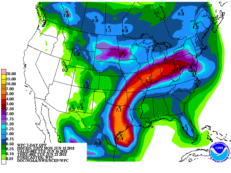
Just saw latest predictions. Basically this storm is headed at everyone I know and love. Dads family lives in BCS/Htown, Dad lives in Missouri bootheel, Moms fam and myself are in WKY.

Posted on 6/15/15 at 8:13 pm to Nguyening
Not to be too flippant but that looks like a dick
Posted on 6/15/15 at 8:14 pm to AgBQ00
hahaha, i think it looks like west virginia is throwing a cheapshot punch at A&M.... Which I guess would be fair play, all things considered.
Posted on 6/15/15 at 8:27 pm to Nguyening
That's odd, my radar doesn't show the cat 5 peckernado

Posted on 6/15/15 at 8:36 pm to Old Sarge
That image was posted by "stringsays" on twitter, it's not the storm image but expected rainfall.... Seems overstated for sure.

 Page 1 of 2

Latest Texas A&M News
Back to top