Started By
Message
Lousiana/Arkansas/SoMo Severe Weather Thread 11/17
Posted on 11/17/15 at 11:22 am
Posted on 11/17/15 at 11:22 am

SPC convective outlook. Puts the best dynamics for severe storms in North La through Southern Missouri.

Jet stream data showing jet split beginning. The enhanced area is basically between where the jets will lie.
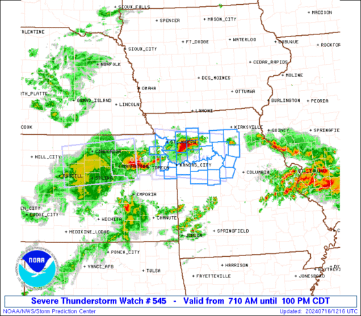
Current Watches:

quote:
URGENT - IMMEDIATE BROADCAST REQUESTED TORNADO WATCH NUMBER 546 NWS STORM PREDICTION CENTER NORMAN OK 1105 AM CST TUE NOV 17 2015 THE NWS STORM PREDICTION CENTER HAS ISSUED A * TORNADO WATCH FOR PORTIONS OF CENTRAL INTO SOUTHEAST ARKANSAS * EFFECTIVE THIS TUESDAY MORNING AND EVENING FROM 1105 AM UNTIL 600 PM CST. * PRIMARY THREATS INCLUDE... A FEW TORNADOES POSSIBLE ISOLATED DAMAGING WIND GUSTS TO 70 MPH POSSIBLE SUMMARY...THUNDERSTORMS SHOULD GRADUALLY INTENSIFY ACROSS THE WATCH AREA THIS AFTERNOON WITH A RISK FOR EMBEDDED SUPERCELL STRUCTURES CAPABLE OF A FEW TORNADOES AND DAMAGING OUTFLOW WINDS. THE TORNADO WATCH AREA IS APPROXIMATELY ALONG AND 65 STATUTE MILES EAST AND WEST OF A LINE FROM 70 MILES NORTH NORTHEAST OF LITTLE ROCK ARKANSAS TO 35 MILES EAST SOUTHEAST OF EL DORADO ARKANSAS. FOR A COMPLETE DEPICTION OF THE WATCH SEE THE ASSOCIATED WATCH OUTLINE UPDATE (WOUS64 KWNS WOU6). PRECAUTIONARY/PREPAREDNESS ACTIONS... REMEMBER...A TORNADO WATCH MEANS CONDITIONS ARE FAVORABLE FOR TORNADOES AND SEVERE THUNDERSTORMS IN AND CLOSE TO THE WATCH AREA. PERSONS IN THESE AREAS SHOULD BE ON THE LOOKOUT FOR THREATENING WEATHER CONDITIONS AND LISTEN FOR LATER STATEMENTS AND POSSIBLE WARNINGS.
LINK
quote:
URGENT - IMMEDIATE BROADCAST REQUESTED TORNADO WATCH NUMBER 545 NWS STORM PREDICTION CENTER NORMAN OK 850 AM CST TUE NOV 17 2015 THE NWS STORM PREDICTION CENTER HAS ISSUED A * TORNADO WATCH FOR PORTIONS OF SOUTHWEST ARKANSAS WESTERN AND CENTRAL LOUISIANA EASTERN AND SOUTHEAST TEXAS COASTAL WATERS * EFFECTIVE THIS TUESDAY MORNING AND AFTERNOON FROM 850 AM UNTIL 400 PM CST. * PRIMARY THREATS INCLUDE... A COUPLE TORNADOES POSSIBLE ISOLATED DAMAGING WIND GUSTS TO 70 MPH POSSIBLE SUMMARY...THUNDERSTORMS SHOULD CONTINUE TO INTENSIFY THIS MORNING INTO AFTERNOON AS ACTIVITY SPREADS FROM WEST TO EAST ACROSS THE WATCH AREA. THE STRONGEST STORMS WILL BE CAPABLE OF A FEW TORNADOES AND LOCALLY DAMAGING WINDS. THE TORNADO WATCH AREA IS APPROXIMATELY ALONG AND 70 STATUTE MILES EAST AND WEST OF A LINE FROM 40 MILES WEST SOUTHWEST OF PORT ARTHUR TEXAS TO 35 MILES NORTHWEST OF EL DORADO ARKANSAS. FOR A COMPLETE DEPICTION OF THE WATCH SEE THE ASSOCIATED WATCH OUTLINE UPDATE (WOUS64 KWNS WOU5). PRECAUTIONARY/PREPAREDNESS ACTIONS... REMEMBER...A TORNADO WATCH MEANS CONDITIONS ARE FAVORABLE FOR TORNADOES AND SEVERE THUNDERSTORMS IN AND CLOSE TO THE WATCH AREA. PERSONS IN THESE AREAS SHOULD BE ON THE LOOKOUT FOR THREATENING WEATHER CONDITIONS AND LISTEN FOR LATER STATEMENTS AND POSSIBLE WARNINGS. &&
LINK
The skinny: Squall line moving out of Texas as part of cold front producing impressive straight line winds. In the "warm" sector ahead of the front, any cells that can get going will have plenty of shear to work with and get spinning.
 6
6

Posted on 11/17/15 at 11:39 am to Duke
Wow, that looks frightening. I hope that system weakens before it reaches Kentucky tomorrow.
Posted on 11/17/15 at 11:43 am to Kentucker
It will. The dynamics won't be there tomorrow. This is typical in fall for severe weather in this part of the world. Nothing too scary.

Posted on 11/17/15 at 12:37 pm to Duke
It's been windy as hell here so when the front passes I'm sure I'll have tons of limbs to pick up. 


Posted on 11/17/15 at 12:41 pm to Kentucker
We should just get some decent rain. I'm more concerned with the drop in temps for the weekend (30s/20s) and what may come next week around Thanksgiving.
Posted on 11/17/15 at 12:55 pm to Duke
That first picture looks like a brontosaurus with a Jay Glazer neck.
Posted on 11/17/15 at 12:57 pm to BallstotheWesleyWall
Yeah, upvote.
Posted on 11/17/15 at 1:12 pm to BluegrassBelle
Yeah, hints at snow flurries from the local weather forecasters. Well, it is November in Kentucky. Time for the coats and gloves.
Posted on 11/17/15 at 1:16 pm to Kentucker
It'll be the SO's first winter north of Mississippi. Hopefully he doesn't freeze. I have a feeling my heating blanket may come up missing.
Posted on 11/17/15 at 1:20 pm to Duke
Hella rain. Occasional lightning earlier.
Posted on 11/17/15 at 4:12 pm to Duke
Been windy as frick in Northeast Landmass today, I expect some wind but that's about it
Posted on 11/17/15 at 4:35 pm to Wishnitwas1998
Looking better and better in this part of the world. No discrete cells have been able to pop off in front of the line and we're past peak hotness.
Posted on 11/17/15 at 4:41 pm to Duke
Lots of wind damage in central Arkansas especially Hot Springs. Tons of rain here , finally slowing down.
Posted on 11/17/15 at 5:04 pm to Hogwarts
Not surprised yall took it on the chin. Best dynamics set up over you.
Posted on 11/17/15 at 5:13 pm to Duke
I see a hook
Posted on 11/17/15 at 10:22 pm to Duke
It's getting real in Jackson. A few rotations around the Madison area and one more between McComb and Jackson. EF0-1 but this storm is getting stronger, churning into a skinnier, but more intense line.
I hope it loses speed as it heads east into the night twd Bama. Stay safe homos
Bad weather is one of the very few things that triggers my PTSD.
I hope it loses speed as it heads east into the night twd Bama. Stay safe homos
Bad weather is one of the very few things that triggers my PTSD.
This post was edited on 11/17/15 at 10:23 pm

Posted on 11/17/15 at 10:44 pm to Duke
had to swim to work.
Posted on 11/17/15 at 11:13 pm to pioneerbasketball
Multiple rotations here in Rankin County. One went a mile N of the house. Man I hope this doesn't flex up more as it seems to be doing.
Posted on 11/17/15 at 11:16 pm to Hardy_Har
Just took a look at the velocities for you. There's one warned just E of Madison that really only looks like a broad roatation.
The one to the north nearish to Brandon is a tornado.
The one to the north nearish to Brandon is a tornado.
Posted on 11/17/15 at 11:25 pm to Duke
I'm 5 mi N of Brandon. It was way off the ground when it came over. I have '100+ trees and the wind barely moved the tops.
It was still enough to get is near the bathroom
It was still enough to get is near the bathroom

 Page 1 of 2

Popular
Back to top