Started By
Message
"Look out, here comes a TORNADO" thread.
Posted on 4/8/15 at 11:17 am
Posted on 4/8/15 at 11:17 am
Killz, yins fudgepackers oughta keep a look out today. I'm sure you already know that tho.
Lots of instability in Missouri. They've moved it south into our area.
Torcon 5, bitches.

Lots of instability in Missouri. They've moved it south into our area.
Torcon 5, bitches.
This post was edited on 4/8/15 at 12:59 pm
 7
7


Posted on 4/8/15 at 11:19 am to Numberwang
We had some storms this morning, but color me concerned that the sun is out right now with more moving in later.

Posted on 4/8/15 at 11:23 am to Numberwang
quote:
Lots in instability in Missouri
No shite

Posted on 4/8/15 at 11:33 am to Rebelgator
frick you for beating me to it 

Posted on 4/8/15 at 12:14 pm to Numberwang
good luck, everyone.
Posted on 4/8/15 at 12:16 pm to Numberwang
SPC Day 1 Outlook and Discussion
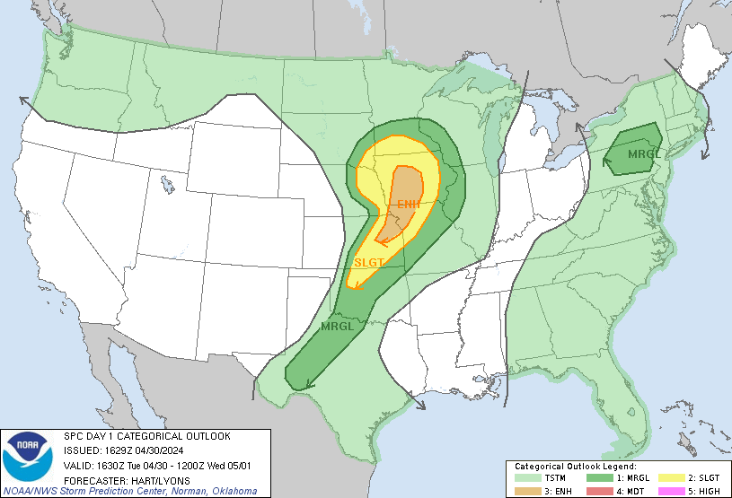

Per the SPC in Norman.
One of the high res. models hits N OK/S KS just east of I-35. Probably the first place I'd look this afternoon. The focus will move east as the evening goes along. At least one model is suggesting from Columbia - St. Louis (everything north of that line) should keep an ear out for the weather reports.
Severe weather season is here.
quote:
...SUMMARY... VERY LARGE HAIL...DAMAGING WIND AND TORNADOES ARE EXPECTED OVER PARTS OF THE CENTRAL PLAINS AND LOWER MISSOURI VALLEY THIS AFTERNOON AND EVENING. OTHER STRONG TO SEVERE STORMS MAY DEVELOP FROM PARTS OF TEXAS NORTHEASTWARD INTO THE OHIO VALLEY AND CENTRAL APPALACHIANS.
quote:
AT THE SFC...APPROACH OF UPR IMPULSES WILL BE ACCOMPANIED BY DEEPENING/CONSOLIDATION OF LEE LOW OVER SE CO LATER TODAY. THE LOW SHOULD TRACK ENE ALONG FRONT NOW STALLING OVER NRN OK/SRN KS INTO NW MO BY THE END OF THE PERIOD. WAVY STNRY/WARM FRONT EXTENDING E FROM THE LOW...AUGMENTED IN PLACES BY MCS OUTFLOW...WILL BE A FOCUS FOR PERIODIC STRONG TO SVR TSTMS THROUGH EARLY THU...WITH OTHER STORMS LIKELY TO FORM LATER TODAY INTO TNGT NEAR THE SFC LOW...AND MORE ISOLD ACTIVITY SSW ALONG TRAILING DRY LINE.
quote:
...SRN/CNTRL PLNS INTO OZARKS LATE THIS AFTN THROUGH EARLY THU... CONDITIONS MAY BECOME INCREASINGLY FAVORABLE FOR A FEW LONGER-LIVED...DISCRETE OR SEMI-DISCRETE SUPERCELLS THIS EVE THROUGH LATE TNGT NEAR AND ENE OF SFC WAVE TRACKING ENE ACROSS S CNTRL KS AND ADJACENT NRN OK/W CNTRL MO. GIVEN THAT THE LOW-LVL FLOW LIKELY WILL APPRECIABLY/STRENGTHEN GIVEN BOTH TIME OF DAY AND THE FAVORABLY-TIMED APPROACH OF BAJA JET MAX...THE CORRESPONDING INCREASE IN LOW-LVL HODOGRAPH LENGTH AND CURVATURE COULD YIELD AN ENHANCED RISK FOR A STRONG TORNADO OR TWO. MORE ISOLD TSTMS WITH A RISK FOR VERY LARGE HAIL AND A COUPLE TORNADOES ARE EXPECTED SSW ALONG DRY LINE INTO W CNTRL TX.
Per the SPC in Norman.
One of the high res. models hits N OK/S KS just east of I-35. Probably the first place I'd look this afternoon. The focus will move east as the evening goes along. At least one model is suggesting from Columbia - St. Louis (everything north of that line) should keep an ear out for the weather reports.
Severe weather season is here.
Posted on 4/8/15 at 12:20 pm to Numberwang
Numberwang
All you gheys in Eureka Springs better watch out! Remember, tornadoes are "the fingers of God" and the local Assemblies of God community says that He doesn't like gheys.
___________________________________
Actually, on my way to work you could see the entire front moving in. Blue cloudless sky to the east, very high cloud updraft to the west. Be careful if you live in Missouri or Arkansas.
This post was edited on 4/8/15 at 12:33 pm
Posted on 4/8/15 at 12:37 pm to Rebelgator
quote:
Lots in instability in Missouri
Basketball season is over so everything's good now
Posted on 4/8/15 at 12:37 pm to Numberwang

Posted on 4/8/15 at 12:59 pm to Duke
Joplin just got rebuilt, too. 
Their new high school is pretty boss, btw.
Their new high school is pretty boss, btw.
Posted on 4/8/15 at 1:00 pm to mizzoukills
Killz, Eureka Springs is safe. They have the world's biggest Good Luck Charm there.

Posted on 4/8/15 at 1:23 pm to Numberwang
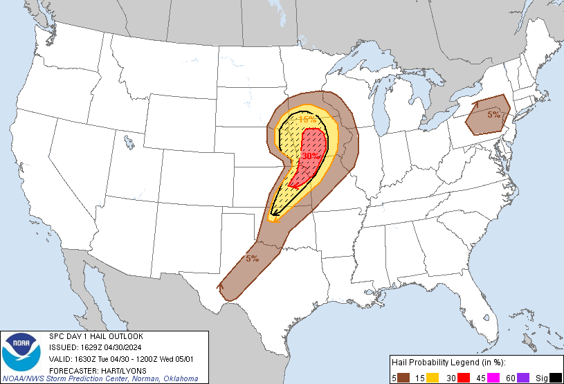
Check out the Day 2 SPC Outlook

That's a monster swath of "enhanced".
Also for today, a more focused map over the most at risk area.

At least Joplin is just on the outside of the moderate risk.
That's a monster swath of "enhanced".
Also for today, a more focused map over the most at risk area.
At least Joplin is just on the outside of the moderate risk.
Posted on 4/8/15 at 1:26 pm to Duke
Thank you for the info. Your geeking on weather is welcome here.
Posted on 4/8/15 at 1:29 pm to Numberwang
Numberwang,
that "good luck charm" was built by a gay hating white supremacist. Don't believe me? Look it up.
that "good luck charm" was built by a gay hating white supremacist. Don't believe me? Look it up.
Posted on 4/8/15 at 1:31 pm to Numberwang
quote:
Your geeking on weather is welcome here.
I've been like this since I was a little kid. Hopefully a few will remember the panic room from last year's deep south outbreak.
Posted on 4/8/15 at 1:31 pm to mizzoukills
I know all that Killz. He's buried on the premises. I've thought for years we should change it to Elvis of the Ozarks.
Posted on 4/8/15 at 1:36 pm to Numberwang
quote:
I've thought for years we should change it to Elvis of the Ozarks.
That would probably draw in FAR more visitors than the current statue.
I love Eureka Springs. Wonderfully weird place to visit on a whim. However, it is very strange that they are cool with a gay hating mega-statue looking down on them all day every day.
I mean, that statue literally looks down upon the entire town...a town full of gays.
Posted on 4/8/15 at 1:42 pm to Duke
I hope we get some strong weather in the Memphis area over the next couple of days cause I love watching storms so much I just wish there was a way to do that and also garuntee no damage would occur
Posted on 4/8/15 at 1:49 pm to Wishnitwas1998
This is the time of year for it. Tomorrow should at least give you the potential for some storm watching. it's rare for us down here to get much severe weather. I have seen quite a few hurricanes though.
Posted on 4/8/15 at 2:07 pm to Wishnitwas1998
We should get some Friday.

 Page 1 of 3

Popular
Back to top